


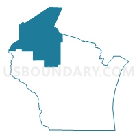
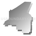
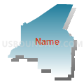
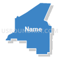
Northwest Wisconsin PUMA, Wisconsin
About
Outline

Summary
| Unique Area Identifier | 194393 |
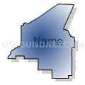
| Name | Northwest Wisconsin PUMA |
| State | Wisconsin |
| Area (square miles) | 13,010.43 |
| Land Area (square miles) | 10,604.31 |
| Water Area (square miles) | 2,406.12 |
| % of Land Area | 81.51 |
| % of Water Area | 18.49 |
| Latitude of the Internal Point | 46.14627420 |
| Longtitude of the Internal Point | -91.07783140 |
Maps

Graphs
Select a template below for downloading or customizing gragh for Northwest Wisconsin PUMA, Wisconsin


Neighbors
Neighoring Public Use Microdata Area (by Name) Neighboring Public Use Microdata Area on the Map
- Barron, Polk, Clark & Chippewa (North) Counties PUMA, WI
- Chisago, Isanti, Pine, Mille Lacs & Kanabec Counties PUMA, MN
- Itasca, Carlton (South), Cass & Aitkin Counties--Grand Rapids City PUMA, MN
- Marathon County PUMA, WI
- Oneida, Lincoln, Vilas, Langlade & Forest Counties PUMA, WI
- St. Louis (North), Koochiching, Lake & Cook Counties--Hibbing & Cloquet Cities PUMA, MN
- St. Louis County (Southeast)--Duluth, Hermantown & Proctor Cities PUMA, MN
- Western Upper Peninsula PUMA, MI
Top 10 Neighboring County (by Population) Neighboring County on the Map
- St. Louis County, MN (200,226)
- Marathon County, WI (134,063)
- Chippewa County, WI (62,415)
- Chisago County, MN (53,887)
- Barron County, WI (45,870)
- Polk County, WI (44,205)
- Douglas County, WI (44,159)
- Oneida County, WI (35,998)
- Carlton County, MN (35,386)
- Clark County, WI (34,690)
Top 10 Neighboring County Subdivision (by Population) Neighboring County Subdivision on the Map
- Duluth city, St. Louis County, MN (86,265)
- Superior city, Douglas County, WI (27,244)
- Ashland city, Ashland County, WI (8,216)
- Ironwood city, Gogebic County, MI (5,387)
- Minocqua town, Oneida County, WI (4,385)
- Medford city, Taylor County, WI (4,326)
- Hayward town, Sawyer County, WI (3,567)
- Lac du Flambeau town, Vilas County, WI (3,441)
- Ladysmith city, Rusk County, WI (3,414)
- Spooner city, Washburn County, WI (2,682)
Top 10 Neighboring Place (by Population) Neighboring Place on the Map
- Duluth city, MN (86,265)
- Superior city, WI (27,244)
- Ashland city, WI (8,216)
- Ironwood city, MI (5,387)
- Medford city, WI (4,326)
- Ladysmith city, WI (3,414)
- Spooner city, WI (2,682)
- Park Falls city, WI (2,462)
- Hayward city, WI (2,318)
- Washburn city, WI (2,117)
Top 10 Neighboring Elementary School District (by Population) Neighboring Elementary School District on the Map
- Minocqua Joint No. 1 School District, WI (6,701)
- Lac du Flambeau No. 1 School District, WI (3,438)
- North Lakeland School District, WI (2,513)
Top 10 Neighboring Secondary School District (by Population) Neighboring Secondary School District on the Map
Top 10 Neighboring Unified School District (by Population) Neighboring Unified School District on the Map
- Duluth Public School District, MN (95,252)
- Superior School District, WI (33,892)
- Merrill Area School District, WI (20,729)
- Rice Lake Area School District, WI (16,147)
- Medford Area School District, WI (14,380)
- Lake Superior Public School District, MN (13,355)
- Hayward Community School District, WI (13,227)
- Ashland School District, WI (12,503)
- Pine City Public School District, MN (10,730)
- Spooner Area School District, WI (10,174)
Top 10 Neighboring State Legislative District Lower Chamber (by Population) Neighboring State Legislative District Lower Chamber on the Map
- State House District 110, MI (83,484)
- Assembly District 28, WI (59,273)
- Assembly District 69, WI (59,107)
- Assembly District 67, WI (58,722)
- Assembly District 73, WI (54,962)
- Assembly District 75, WI (54,961)
- Assembly District 34, WI (53,812)
- Assembly District 35, WI (52,716)
- Assembly District 87, WI (52,707)
- Assembly District 74, WI (52,623)
Top 10 Neighboring State Legislative District Upper Chamber (by Population) Neighboring State Legislative District Upper Chamber on the Map
- State Senate District 38, MI (261,728)
- State Senate District 10, WI (192,662)
- State Senate District 23, WI (176,958)
- State Senate District 29, WI (167,310)
- State Senate District 25, WI (162,546)
- State Senate District 12, WI (157,332)
- State Senate District 17, MN (94,415)
- State Senate District 8, MN (81,987)
- State Senate District 6, MN (76,702)
- State Senate District 7, MN (72,235)
Top 10 Neighboring 111th Congressional District (by Population) Neighboring 111th Congressional District on the Map
- Congressional District 8, WI (706,840)
- Congressional District 7, WI (689,279)
- Congressional District 8, MN (660,342)
- Congressional District 1, MI (650,222)
Top 10 Neighboring Census Tract (by Population) Neighboring Census Tract on the Map
- Census Tract 704, Carlton County, MN (7,822)
- Census Tract 23, Marathon County, WI (7,169)
- Census Tract 1102, Chisago County, MN (6,967)
- Census Tract 301, Douglas County, WI (6,247)
- Census Tract 10.02, Barron County, WI (5,572)
- Census Tract 8, Barron County, WI (5,435)
- Census Tract 9505, Washburn County, WI (5,100)
- Census Tract 303, Douglas County, WI (5,066)
- Census Tract 9504, Pine County, MN (5,047)
- Census Tract 302, Douglas County, WI (5,027)
Top 10 Neighboring 5-Digit ZIP Code Tabulation Area (by Population) Neighboring 5-Digit ZIP Code Tabulation Area on the Map
- 54880, WI (30,772)
- 54452, WI (19,360)
- 54868, WI (15,512)
- 54806, WI (11,810)
- 54451, WI (11,755)
- 54843, WI (11,487)
- 55807, MN (9,963)
- 55806, MN (9,576)
- 55063, MN (9,348)
- 49938, MI (7,945)